Apogee-D: High Accuracy Dual Antenna GNSS/INS

HomeApogee-D: High Accuracy Dual Antenna GNSS/INS

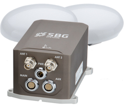
Apogee-D is a highly accurate Inertial Navigation System with dual antenna GNSS receiver for real-time and post-processing operations. The ITAR Free Apogee-D is the most accurate Dual GNSS/INS based on the robust and cost-effective MEMS technology.

High Accuracy:

  • 0.008° Roll & Pitch (RTK)
  • 0.025° GNSS-based Heading  (4m baseline)
  • 1 cm    Position (RTK)
  • Post-processing with Qinertia INS/GNSS PPK Software
  • 5 cm    Real-time Heave
  • 2 cm    Delayed Heave

Apogee-D embeds:

  • The latest MEMS gyroscopes and accelerometers
  • The latest tri-frequency GNSS receiver with one Survey grade antenna
  • A Web Interface for Easy Configuration
  • A 48h Internal Data Logger for Post-processing

Dual Antenna Tri-frequency GNSS receiver – RTK, TerraStar, Veripos Positioning

This state-of-the-art INS/GNSS integrates the last generation of Tri-frequency GNSS receiver which supports RTK, TerraStar and Veripos positioning services. Apogee-D comes with a dual antenna GNSS receiver for accurate and robust heading even under low dynamics (marine) and for an extremely fast initial alignment time.

Extensive Heave Calculation

The Apogee provides a real-time heave accurate to 5 cm. For more simplicity, the user doesn’t have to enter the wave frequency; the Apogee automatically detects it and constantly adjusts to it.

Apogee comes also with a unique delayed heave feature with no additional software nor user action. This specific algorithm allows a more extensive calculation, resulting in a heave accurate to 2 cm displayed in real-time with a little delay.

Applications:

Land

Choose the Apogee-D when accurate heading is needed and a large baseline (minimum 2 m) can be respected on the land vehicle. Apogee-D can be used for any vehicle navigation encountering GPS outages. This cutting-edge Dual GNSS/INS still provides reliable and accurate trajectory when connected to an odometer.

Aerospace

Apogee-D is the ultimate INS for Aerial Mapping, Photogrammetry or Remote Sensing projects. Thanks to its very low noise gyroscopes, it delivers accurate and stable orientation and position data, both real time or post processing. It’s also a cutting edge solution for strategic UAV navigation and advanced payload stabilization. It embeds a dual antenna GNSS receiver for accurate heading during long steady flight phases.

Complementary Equipment and Software

Connection, Synchronization, and Positioning

The SplitBox provides a simplified interface for easy connection and synchronization with external equipment such as odometer, differential corrections, computers, or survey instruments. The SplitBox with integrated GNSS receiver additionally delivers navigation data with a large choice of positioning services (Marinestar, TerraStar, etc.).

Qinertia INS/GNSS Post-processing Software

Qinertia is the SBG Systems in-house post-processing software. This full-featured software enhances SBG inertial navigation systems performance by post processing inertial data with raw GNSS observables.

pattern
https://www.zenmicrosystems.co.in/wp-content/themes/blake/
https://www.zenmicrosystems.co.in//
#ef3e35
style3
paged
Loading posts...
/home/zenmicrosystemsc/public_html/
#
on
none
loading
#
Sort Gallery
https://www.zenmicrosystems.co.in/wp-content/themes/blake
on
no
off
ENTER YOUR EMAIL HERE!
off
off